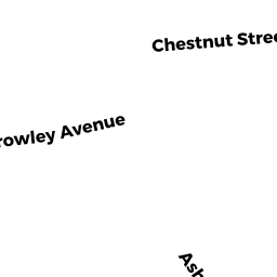
73 CHESTNUT ST
Owner Information
LANGUIRAND KATHY A
73 CHESTNUT ST
NORTH ADAMS, MA 01247


Property Details
73 CHESTNUT ST is classified as a Single Family Residential (Old style).
The primary structure on this property was built in 1900. There are 1,862ft2 of built area within this property. There is 1,862ft2 of residential/living space within this property. This property is listed as having 10 rooms.
73 CHESTNUT ST is valued at $162,300. The land is valued at $31,000 and the structures are valued at $129,000. There is an additional valuation of $2,300 on this property.
The most recent deed for 73 CHESTNUT ST is recorded at the local registrar in Book 1616, Page 587. 73 CHESTNUT ST was last sold on Friday, February 10, 2017 for $145,000.
Assessment data from fiscal year 2022.
Flood Data
According to the FEMA National Flood Hazard Layer, this property does not appear to be in a flood zone. It may also be in an area not yet reviewed. Nonetheless, confirm this information prior to taking any action.
To view the flood hazards around this property, create a FEMA "Firmette" Map of the area around 73 CHESTNUT ST.
Broadband Internet Providers
| Provider | Type | Bandwidth (mbps) | |
|---|---|---|---|
| Viasat Inc | Satellite | 35 | 3 |
| Charter Communications Inc | Cable | 940 | 35 |
| Verizon New England Inc. | DSL | 15 | 1 |
| GCI Communication Corp. | Satellite | 0 | 0 |
| HughesNet | Satellite | 25 | 3 |
| VSAT Systems, LLC. | Satellite | 2 | 1 |
Broadband service provider data from December 2020.